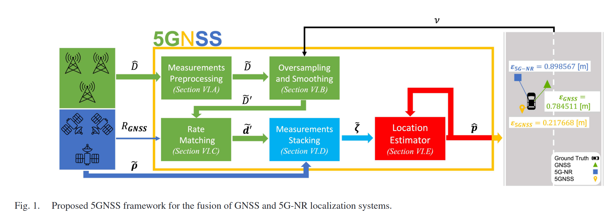
5GNSS: Fusion of 5G-NR and GNSS Localization for Enhanced Positioning Accuracy and Reliability
Abstract—With the proliferation of connected devices and the increasing demand for more precise and reliable positioning information, the fusion of 5G and GNSS localization systems holds immense potential to overcome the current limitations of standalone approaches. In order to tackle this challenge, in this paper we explore the potential of the fusion of 5G-NR and satellite localization systems to jointly enhance their accuracy and reliability. The designed solution, termed 5GNSS, is explained in detail, describing its five main building blocks and corresponding mathematical foundations. An extensive performance evaluation has been conducted, considering urban, suburban, and rural vehicular scenarios, as well as a varying number of visible satellites and 5G base stations. Our results show that 5GNSS can outperform standalone GNSS, 4G-LTE and 5G-NR positioning systems consistently across all these scenarios with an average error reduction in the ∼ 60-40% range. Based on these results, we conclude that future positioning systems would strongly benefit from incorporating 5GNSS-like fusion solutions.
[!CAUTION]
- Node (the known position), 2D(x, y)/3D(x, y, z) $, p_n = \left(x_n, y_n\right)$, $n=1,\dots,N$
- Objection (to be estimated)
Each satellite broadcasts a signal containing a ranging code and a data message; the code indicates the transmission time of the signal while the message includes parameters and information about the satellite’s orbit.
Fusion position (5G+GNSS+other)
多源数据融合/根据场景进行加权/何种轨道卫星?
Ref Survery: Survey on Opportunistic PNT With Signals From LEO Communication Satellites ( IEEE Communications Surveys & Tutorials)
Abstract—Ranging bias mitigation is a critical technique for improving localization accuracy, and it becomes especially challenging when prior state information is unavailable. In this paper, we propose a robust estimator that leverages the sparsity of measurement biases to address the lack of prior information and achieves position estimation based on convex-concave programming (CCP). Specifically, we introduce an auxiliary variance amplification parameter to identify measurement anomalies and construct the optimization problem based on maximum likelihood estimation (MLE), which can be equivalently transformed into an ℓ1-regularized form. To address the non-convexity challenge, the original problem is transformed into difference-of-convex-functions (DC) programming using second-order cone relaxation (SOCR) and semidefinite relaxation (SDR), and solved by CCP. On this basis, we propose a joint SOCR-CCP and SDR-CCP (JSSC) algorithm that leverages the respective advantages of SOCR and SDR. The Rao test is incorporated into this algorithm to reduce complexity and enhance stability. Finally, numerical results demonstrate that the proposed methods outperform various state-of-the-art competing methods.
Fusion Positioning of GNSS-Cellular Signals of Opportunity Under Low Observability
Abstract—Cellular signals of opportunity (CSOPs) can be utilized as a backup positioning system for global navigation satellite systems (GNSSs) in urban. Current studies on the fusion of GNSS-CSOPs require sufficient signals. However, in low-observability environments where the total number of visible signals does not exceed four, the existing GNSS-CSOPs pseudorange fusion methods lack robust strategies and have poor performance. In addition, GNSS-CSOPs are not spatiotemporally synchronized and have not yet been considered by current studies. Moreover, GNSS-CSOPs pseudorange measurements noise exhibit differences under the kinematic receiver, and this challenge has not been well dealt with by the existing weighting methods. To address the above-mentioned issues, a novel fusion positioning system based on an iterated extended Kalman filter (IEKF) for GNSS-CSOP is formulated under low observability, and the degree of observability is analyzed. In this system, the influence of spatiotemporal asynchronicity is addressed. Then, a Helmert unit variance estimation (HUVE) algorithm is proposed to obtain the measurement weights in GNSS-CSOPs fusion. Moreover, a double Dog-leg incremental estimation (DDIE) algorithm is proposed to enhance convergence when solving under low observability. In field tests, results show that the positioning accuracy of the proposed system can reach approximately 6.5 m under low observability. Compared with other state-of-the-art studies, such as weighting with power-of-signal, quasi-Newton (QN), Levenberg-Marquardt (LM), and Dog-leg methods, the performance of the proposed system has been improved by 62.4%, 82.4%, 72.9%, and 64.7%, respectively. This study presents a novel fusion positioning strategy for the GNSS-CSOP in low-observability environments.
SDP 感知数据集
Dataset Overview
Wi-Prox is a simulation dataset for Wi-Fi device proximity detection released by the MobiSense group at Tsinghua University. It contains channel state information (CSI) obtained through MATLAB simulation toolbox, and the corresponding real proximity distances of devices. The dataset contains 323K samples from 550 different device placement combinations.
Data File Description
File format: mat
File tree structure: There’s only one layer of files.
Dataset size: 2.33 GB
Data volume: 258K samples
Data type: Wi-Fi CSI data
Data collection duration: 720 min
Data format:
wi-prox.mat parsing yields three sets of data with the same dimension and [550,1], iot_csi, ue_csi, and dist_val, which correspond to the CSI of the IoT, the CSI of the UE, and the proximity distance between the IoT and the UE. Where 550 indicates a total of 550 different deployment scenarios. For each deployment scenario: iot_csi is a 3D tensor of the form [N,S,A], where N is the number of IoT devices (fixed at 6), S is the number of subcarriers (fixed at 56), and A is the number of antennas (fixed at 9) ue_csi is a 3D tensor in the form of [M,S,A], where M is the number of UE devices that can communicate with all IoT devices, S is the number of subcarriers (fixed at 56), and A is the number of antennas (fixed at 9) dist_val is a 3D tensor in the form of [M,N], where M is the number of UE devices that can communicate with all IoT devices, N is the number of IoT devices (fixed at 6)
| dist_val | iot_csi | ue_csi | Note |
|---|---|---|---|
| 550*1 cell | 550*1 cell | 550*1 cell | 550 different deployment scenarios |
| [N,S,A] N=6(the number of IoT devices) S=56(the number of subcarriers) A=9(the number of antennas) |
|||
File naming rules: Data packaged as wi-prox, including variable names: iot_csi, ue_csi, dist_val
Detailed description: The device deployment scheme is shown in the figures of the collection scenario. The Wi-Fi protocol is 802.11n, the frequency band is 5.8 GHz, the bandwidth is 20 MHz, and the packet rate is 1000 Hz.
Collecting Scenarios And Device Information
Collection scenarios: home scenerio
Collection time:2023.03-2023.05
Schematic diagram of collection scenario:
Frequency band: 5.8 GHz
Bandwidth: 20 MHz
Protocol: 802.11n
Waveform: OFDM
Sampling rate: 1000 Hz
Antenna: The UE is equipped with a 3×3 9-antenna square array, and the AP is equipped with a single antenna
Segment flag/Time segment length: Each device deployment case is stored by a cell